
Beskid Niski
from Krynica-Zdrój to Komańcza
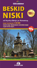
scale
legend
size
1st edition
author
publishers
ISBN
1:50 000
5 languages
97 x 67 cm
2009
Michael Siwicki
978-83-87873-44-8

Beskidy maps
distribution
![]()
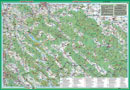
The map covers whole Beskid Niski, on both sides.
The explanation contains about 90 signs, described in 5 languages (PL, GB, D, F, SK). Vivid hill shading in two colours with 20-m interval countour lines clearly show the relief. There is geographical grid for GPS here, time distances and mountain bike routes, as well as routes for horse-riding and skiing.
On back side you can find several informations about the region. There is schema of touristic routes there as well as touristic guide, accommodatrion guide and landscape directory.