
Beskid Mały
Jezioro Międzybrodzkie (Międzybrodzkie Reservoir)
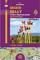
scale
legend
size
1st edition
author
publishers
ISBN
1:50 000
5 languages
82 x 56 cm
2004
Michael Siwicki
83-7499-015-5
Beskidy maps
distribution
![]()
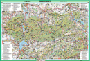
The map covers whole Beskid Mały, from Bielsko-Biała to Sucha Beskidzka, from Wadowice and Andrychów to Jeleśnia.
The explanation contains about 90 signs, described in 5 languages (PL, GB, D, F, SK). Vivid hill shading in two colours with 20-m interval countour lines clearly show the relief. There is geographical grid for GPS here, time distances and mountain bike routes.
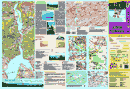
On back side you can find several informations about the region. There is the the panorama here and comprehensive touristic directory. You can find a city-map of Sucha Beskidzka, Żywiec, Wadowice and Kalwaria Zebrzydowska too, several informations about landscape park, coverage of mobile phones.